Population mountains

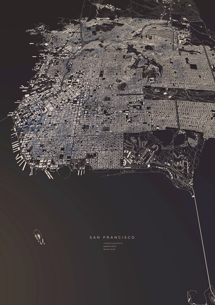
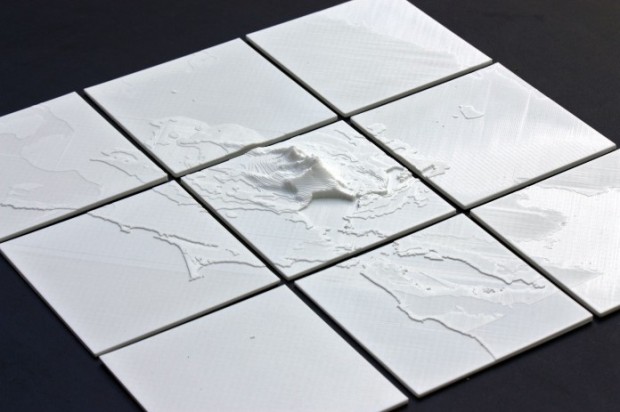
You’ve seen the maps of population density. You’ve seen the jokes. But you haven’t seen population at high granularity in a 3-D view. Matt Daniels for The Pudding used a mountain metaphor to show the peaks and valleys of population around the world.

You get more out of the data in this view than you would the overhead, which tends to obscure the variation in large cities. Although if you must, Daniels also provides the typical view to reference.

Tags: , ,

Inside Hurricane Maria, a 3-D perspective

This 3-D view inside Hurricane Maria, from NASA’s Scientific Visualization Studio and NASA’s Goddard Space Flight Center, lets you see the data and the lead-up to the storm in a neat 360-degree view. Be sure to watch it on your phone or with a VR thingy for full effect. Disregard the questionable color scale.

Tags: , , ,

3-D view inside Typhoon Mangkhut

Typhoon Mangkhut went through the northern end of the Phillipines a few days ago. At least 25 people died. The New York Times provides a scrolling 3-dimensional view using data collected by NASA satellites.

Tags: , , ,

All the buildings in Manhattan in 3-D map

Taylor Baldwin mapped all of the buildings in Manhattan using a 3-D layout. Rotate, zoom, and pan, and be sure to mess around with the parameters in the control panel for different looks. Also make sure you try it in Chrome, because it’ll probably send your computer fan whirling.

Tags: , ,

City layouts in 3-D

Manhattan

Luis Dilger made a set of fine-looking prints that show city landscapes in 3-D. They look like little cardboard cutouts.

I didn't only want to show these structures in the conventional way from above, but also including the exact three-dimensionality of topography and buildings - a real world visualisation.

The OpenStreetMap data enabled me to visualize the satellite-based information using DEM Earth in Cinema 4D. The results are some extraordinary views of large capitals and small towns.

Other cities include Copenhagen, Hamburg, Berlin, Paris, and others. Here's the one for San Francisco:

San Francisco

Get yourself a copy.

Tags: , ,

Convert geographic data to 3-D models for printing

3d printed map data

This seems like fun. The NodeJS package shp2stl by Doug McCune lets you convert a shapefile to a 3-D model, which can then send to your favorite 3-D printer (because you know we all have at least two of them lying around). Assuming you have NodeJS setup, simply point the package to your shapefile, specify which attribute to use for height, and presto changeo there's your 3-D model.

Tags: , , ,

3-D model to show free-climb route

Dawn Wall

Tommy Caldwell and Kevin Jorgeson are free-climbing almost 3,000 feet up El Capitan, basically with their fingers. The New York Times shows the ascent with a route placed on top of a 3-D model. Scroll in a WebGL-enabled browser on the biggest screen possible for a smidgen of feeling for what the climb is like.

See also Caldwell's Facebook page for some amazing pictures of what they've experienced so far.

Update: The Times just published a high-res image of the wall. Click on the links in the caption to see Jorgeson, but a tiny speck.

Tags: , ,