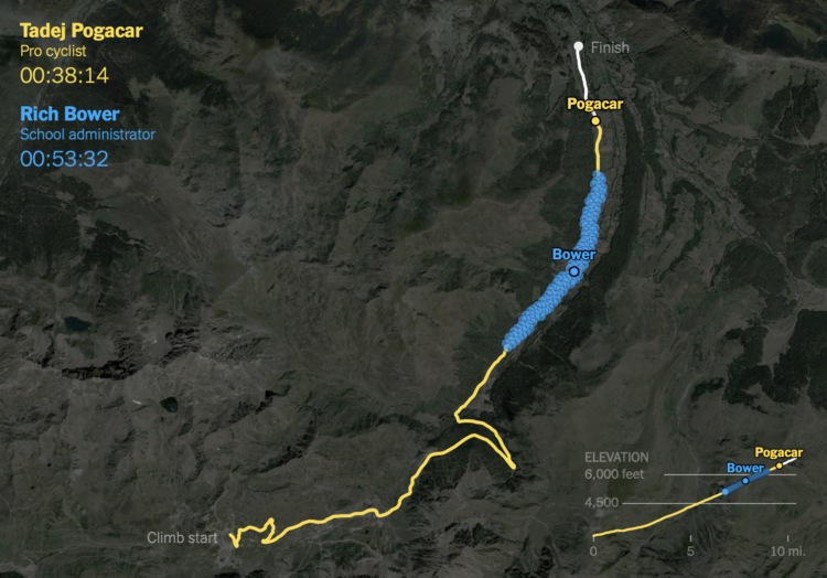
Racing amateurs against Tour de France cyclists

It takes strength and dedication to race in the Tour de France. It’s just that when you see the leading cyclist alone on a steep climb, they kind of look the same as some random person riding up a hill. For NYT’s The Upshot, K.K. Rebecca Lai and Ben Blatt provide a point of comparison.

Data from Strava was used to show how a caterpillar-like group of amateurs rode against a professional. As you might have guessed, the professional climbs much faster. Just a tad.

Tags: , , , ,

Tracking her boyfriend on Strava

Elizabeth Barber was in a long-distance relationship, and Strava was a way for her to connect with him. It became a point of anxiety when her boyfriend cycled with someone else more and more often.

I was curious, and Strava is a joyless data bank for the insecure. When The Washington Post reported in January that US military bases are visible in the GPS shadows of uniformed Stravites, I was not shocked. I had performed equally fastidious forensics on the cyclist’s Strava maps. Tracing her routes on that anxious morning and days to come, I could see where she lived, where she drank beer and got coffee. I knew how many calories she burned working out, and how often. I knew when and where and with whom she spent time (increasingly, my boyfriend).

Data without much context: enough to drive anyone a little nutty.

Tags: , ,

Secret army bases seen in public fitness tracking map

Last year, fitness tracking app Strava released a high detail map of public activity data. Looking more closely, security student Nathan Ruser noticed activity in various parts of the globe that revealed secret US army bases.

Alex Hern for The Guardian reports:

Zooming in on one of the larger bases clearly reveals its internal layout, as mapped out by the tracked jogging routes of numerous soldiers. The base itself is not visible on the satellite views of commercial providers such as Google Maps or Apple’s Maps, yet it can be clearly seen through Strava.

Outside direct conflict zones, potentially sensitive information can still be gleaned. For instance, a map of Homey Airport, Nevada – the US Air Force base commonly known as Area 51 – records a lone cyclist taking a ride from the base along the west edge of Groom Lake, marked on the heatmap by a thin red line.

While Strava certainly needs to be responsible for what they’re mapping (especially because they know how many of their users publicly share routes by default), the users need to take better care in what they share.

Or maybe this isn’t sensitive information and is blown out of proportion. I don’t know. I feel like it is though. In which case I’d argue that they should avoid public-facing GPS-based services, which are essentially social media for location.

Tags: , ,

Global cycling and running heatmap

A few years back, cycling and running app Strava mapped the paths of its users. Now with a lot more data and the challenges that come with that, Strava provides a more fine-tuned rendering of where the world cycles and runs.

Beyond simply including more data, a total rewrite of the heatmap code permitted major improvements in rendering quality. Highlights include twice the resolution, rasterizing activity data as paths instead of as points, and an improved normalization technique that ensures a richer and more beautiful visualization.

Tags: , ,