Snow cover mapped using snowflakes

To show snow cover across the United States, Althea Archer for the USGS used hexbins, but instead of hexbins, she used snowflakes. Archer provided her R code and outlined her process in a blog post, which is something I’m not used to seeing from a government agency. I like it.

Tags: , , ,

Mapping the sea floor

Jon Keegan on how USGS researchers collected data for 125 square miles of sea floor:

In 2004 and 2005, two research vessels, Ocean Explorer and Connecticut set off into the waters off Cape Ann, Massachusetts on a U.S. Geological Survey mission to map a section of the bottom of the sea. Equipped with cameras, advanced sonar and bathymetric scanners, these ships mapped 125 square miles of the sea floor capturing a detailed dataset that allowed U.S. Geological Survey scientists to characterize the makeup of the sediment and bedrock in waters up to 92 meters deep.

Tags: , , ,

Where America is expanding in developed areas

Zach Levitt and Jess Eng for The Washington Post mapped newly developed areas in the contiguous United States, between 2001 and 2019:

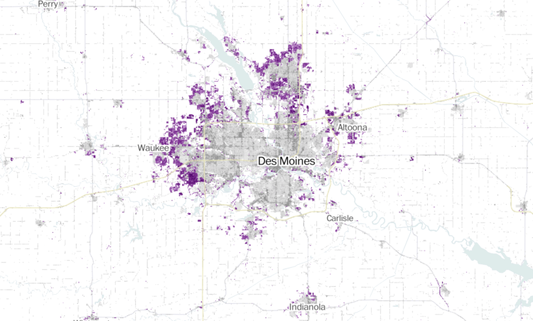
Between 2001 and 2019, the built-up landscape of America — buildings, roads and other structures — has expanded into previously undeveloped areas, adding more than 14,000 square miles of new development across the contiguous United States — an area over five times the size of Delaware.

My favorite part is the interactive map, which lets you see development in your area. The purple indicating newly developed areas against the grayscale provides a quick reference.

The maps are based on data from the United States Geological Survey, which you can grab here.

Tags: , , ,

First unified geologic map of the moon

The USGS released a unified geologic map of the moon on a 1:5,000,000-scale — and the data to go with it:

This new work represents a seamless, globally consistent, 1:5,000,000-scale geologic map derived from the six digitally renovated geologic maps (see Source Online Linkage below). The goal of this project was to create a digital resource for science research and analysis, future geologic mapping efforts, be it local-, regional-, or global-scale products, and as a resource for the educators and the public interested in lunar geology. Here we present the completed mapping project as unit contacts, geologic unit polygons, linear features, and unit and feature nomenclature annotation.

That paintball aesthetic is quite becoming.

Tags: , ,

BellTopo Sans is is a free typeface based on maps from 1800s

While working on maps inspired by USGS maps from the 1800s, Sarah Bell made a typeface to match:

While making my own USGS-inspired maps, my search never returned the exact type of font I was looking for. The fruitless search was serendipitous however, because it provided the push to make my own. It was designed for map labels that are no larger than 80-100pt, but usually much smaller. I decided to name it BellTopo Sans with the plan to create a serif version.

She made it available here.

Tags: , ,