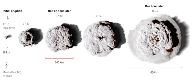
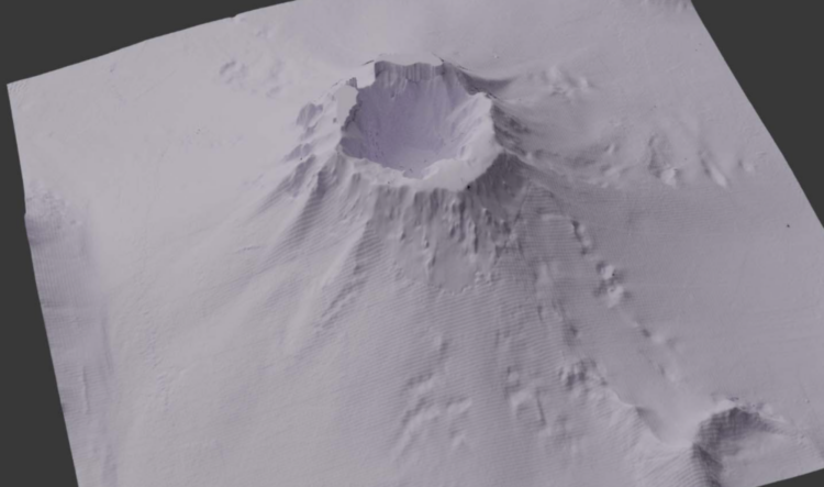
Mark Doman and Alex Palmer, for ABC News, show the depth of the Tonga volcano that erupted earlier this year with a 3-D model. “While the depth of the caldera shocked him, the fact the rest of the volcano appeared to be largely unchanged was equally as surprising.”
Tag Archives: volcano
Scale of the Tonga eruption
Manas Sharma and Simon Scarr used satellite imagery to show the scale of the Tonga eruption, which spurted a 24-mile cloud that grew to 400 miles in diameter in an hour. Notice the little Manhattan in the bottom left corner in the image above.
However, instead of leaving it at that, Sharma and Scarr animated the eruption over familiar geographic areas to better see how big it was. The cloud was big enough to cover whole countries.
Tags: Reuters, satellite imagery, scale, Tonga, volcano
Global ripple effect from underwater volcano
An underwater volcano erupted about 40 miles off the coast of the main island of Tonga. Using infrared data from the GOES satellite operated by NOAA, Mathew Barlow animated the ripple from the the source to around the world.
— Dr. Mathew Barlow (@MathewABarlow) January 16, 2022
The filtered view, which shows band 13 data from the satellite’s sensors, typically to view cloud cover, is really something.
All the volcano eruptions
Slowly becoming the person who charts the past century of natural disaster events, Lazaro Gamio for Axios uses a pictogram to depict all known volcano eruptions since 1883. The vertical position represents elevation, color represents number of eruptions since 1883, and the shape represents volcano type.
I wonder if you get anything out of looking at eruptions over time. This view is more compendium than pattern revealer. You can grab the data from the Global Volcanism Program to check it out yourself.
Posted by Axios, Infographics, volcano
in