If people were asked where in the United States do most earthquakes happen, they are likely to answer California. They’d be correct.(1) But earthquakes are a hazard in other parts of the country, too.
The U.S. Geological Survey (USGS) estimates that nearly half of all Americans live in areas with some potential for damaging earthquakes. That includes people living in the central states where there is what USGS calls “strong shaking potential.”(2)
If you live under the threat of earthquakes, there are ways you can prepare. They start with collecting emergency supplies, including personal needs, and planning ahead. Here are three more ways you can prepare.
Know Your Risk
There’s no way to know when or where an earthquake will happen. The best scientists can do is calculate the probability that a significant earthquake will happen in a specific area within a certain number of years.(3)
It is, however, possible to better know the earthquake hazard where you live and the earthquake risk to your community.
An earthquake hazard is anything associated with an earthquake that may affect the normal activities of people. This includes landslide, liquefaction, tsunamis, and seiches.(4)
Use the USGS National Seismic Hazard Map to learn the general earthquake hazard in your area. The map shows how many times earthquakes could cause damaging ground shaking in 10,000 years. That doesn’t mean the earthquakes won’t happen before. They could happen at any time.(5)
Your earthquake risk is the probable building damage and the number of people that are expected to be hurt or killed if an earthquake occurs on a particular fault. Earthquake risk and earthquake hazard are sometimes incorrectly used interchangeably. High earthquake hazard does not mean high risk.(6)
The best way for you to stay informed about both the hazard and risk to your community is to contact your local emergency management or geological survey office. Understanding your risk can help you take steps to protect yourself and your property.
Earthquakes can trigger tsunamis. A tsunami can strike any U.S. coast, but the hazard is greatest in places near subduction zones. For example, Hawaii, Alaska, Washington, Oregon, California, and the U.S. Caribbean islands. If you live along the coast in one of these places, you are at risk from tsunamis.
Practice Your Response
Earthquakes can have immediate and long-term impacts on health and safety. They can cause injuries, anxiety and stress, and death.(7)
Participating in emergency response activities like the Great ShakeOut earthquake drill can teach you practical skills that you can use during an earthquake. Take these steps:
STOP and stay put. Stay inside if you are inside and outside if you are outside. If inside and if possible, move away from glass, hanging objects, bookcases, cabinets, and large furniture that could fall. If you are outside, move away from buildings, utility wires, and fuel and gas lines.
DROP down onto your hands and knees. This position protects you from falling but allows you to still move if necessary.
COVER your head and neck (and your entire body if possible) underneath a table or desk. If there is no shelter nearby, get down near an interior wall or next to low-lying furniture that won’t fall on you, and cover your head and neck with your arms and hands. If you are in bed, hold on and stay there. Protect your head with a pillow.
HOLD ON to your shelter (or to your head and neck) until the shaking stops. Be prepared to move with your shelter if the shaking shifts it around.
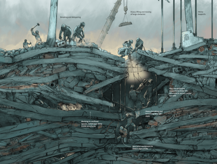
Studies of injuries and deaths caused by earthquakes over several decades show that you are much more likely to be injured by falling or flying objects than to die in a collapsed building.(8)
Imagine your home or workplace being picked up and shaken sideways. What would be thrown around and cause injury or damage?
Reduce your risk of injury by taking no-cost steps to secure the space around you:
Move or secure furniture, such as bookcases, away from beds, sofas, or other places where people sit, sleep, or spend a lot of time.
Move heavy objects to lower shelves.
Move heavy or unstable objects away from doors and escape routes.(9)
Consider buying earthquake insurance if you have the means and live someplace where there’s a high earthquake hazard. Standard homeowners’ and renters’ insurance policies do not cover damage resulting from land movement or landslides.
Earthquake insurance isn’t a realistic option for everyone. Increases in insurance premiums have made it difficult to find coverage in many areas. California experiences 90% of the country’s earthquakes, but only 10% of residents had earthquake insurance in 2014.(10)
There are many things to consider when deciding whether to buy earthquake insurance. They include how often earthquakes happen in your area, how long it’s been since the last earthquake, the value of your home and its contents, and the cost of the insurance and restrictions on coverage (i.e., the deductible).(11)
Thanks in advance for your questions and comments on this Public Health Matters post. Please note that CDC does not give personal medical advice. If you are concerned you have a disease or condition, talk to your doctor.
Have a question for CDC? CDC-INFO (http://www.cdc.gov/cdc-info/index.html) offers live agents by phone and email to help you find the latest, reliable, and science-based health information on more than 750 health topics.
The New Year is the time many of us make resolutions for the coming year. Sometimes resolutions feel too big and long-drawn-out to accomplish. As a result, our motivation to see them through can peter out before the end of the year.
This year, instead of making one resolution for the year, make 12 micro-resolutions. Focusing on one thing each month can make it easier for you to reach your goal, whether it’s to quit smoking or prepare your health for emergencies.
Here are some example micro-resolutions you can make this year to improve your personal health preparedness.
January
January is Get Organized Month. Get organized by creating a checklist of your personal needs. Being organized can help you stay calm during an emergency. Ways to get organized include using checklists to help you collect emergency supplies and scanning important paperwork.
February
Just 35% of respondents to a recent Healthcare Ready survey said they could list all their prescription details if they had to evacuate their homes without their medicines or medical supplies.(1)
You don’t have to memorize the details of your prescriptions. Instead, make a list of your medicines, including information about your diagnosis, dosage, frequency, and medical supply needs. Make an annual appointment with your doctor to discuss your prescriptions and how you can create an emergency supply of them.
March
National Proofreading Day is observed in March. Organize, check, correct, and protect your important paperwork, such as medical records, insurance (e.g., flood and earthquake) documents, action plans, etc. Examples of common errors found in medical records include
Missing or outdated personal information.
Missing information about a new medication or allergy.
Missing or incorrect information about your health history or the date of your visit.
Mischarges for a test you didn’t have.(2)
April
Practice your emergency action plan with your entire family, including pets. Take the 10-minute evacuation challenge. Set a timer for 10 minutes. In those 10 minutes, see if everyone can:
Put on long pants, a long sleeve shirt or sweatshirt, shoes, and a hat.
Take emergency supplies and other important things to the car.
Find your pets, put them in carriers if they have them, and take them to the car.
Pack the car.
Get in the car and buckle your seatbelt.
May
May is National Wildfire Awareness Month. Create defensible space if you live in an area prone to wildfires. Defensible space is a buffer you create between your home or another structure on your property and the grass, trees, shrubs, or any wildland area around it.
June
The Atlantic hurricane season begins June 1 and ends on November 30. Be prepared to evacuate in case you find yourself in the path of a storm:
Collect emergency supplies and create “go kits” for your family.
Test drive your evacuation route to identify detours, gas stations, emergency departments, urgent cares, veterinarians, etc. along the route.
Emergency supplies expire. Check your supplies regularly so you can be sure they’re safe to use when you need them. Remove, throw away or use, and replace any food and water, prescription medications, and supplies every six (6) months.
August
August 15 is National Check the Chip Day. Microchipping your pet(s) is one of the best ways to ensure that you and your pet are reunited if separated during an emergency. Remember to register the microchip with the manufacturer and to keep your contact information up to date.(3)
Also, keep a photo of your pet with your important paperwork to help with identification and as proof of ownership.
September
Get a flu shot. It’s best to be vaccinated before flu begins spreading in your community. September and October are generally good times to be vaccinated against flu. Ideally, everyone should be vaccinated by the end of October. Even if you are not able to get vaccinated until November or later, vaccination is still recommended because flu most commonly peaks in February and significant activity can continue into May.(4)
October
Participate in emergency drills and exercises like the Great ShakeOut earthquake drill for practice and the peace of mind of knowing how to respond to an earthquake. The Great ShakeOut is held annually on October 21. The drill is an opportunity for you to practice how to “Drop, Cover, and Hold On” during an earthquake or aftershock.
November
Take action to protect yourself and others from carbon monoxide poisoning and house fires. Change the batteries in your carbon monoxide (CO) detectors and smoke alarms at the beginning and end of Daylight-Saving Time. If you own a generator, know how to operate it safely during a power outage.
December
There are ways to prepare for emergencies that have nothing to do with collecting supplies. Learning practical skills, like CPR and seizure first aid, is also important to your health preparedness. Many practical skills don’t require special certification or formal training to perform, but you do need education. Seek out local volunteer organizations that can help you learn these types of skills.
There are many ways you can improve your emergency preparedness without being overwhelmed. Doing one thing each month can help you be prepared for an emergency that can happen anytime. Make sure how you prepare aligns with your needs and those of your family.
A beachy keen day can turn into anything if you aren’t prepared. Here are some things you should know before you go to the beach.
How to Swim in the Ocean
Swimming in the ocean isn’t like swimming in a pool. Waves, currents, and winds can drain your energy and strength. Rough surf and rip currents are especially dangerous if you aren’t already a strong swimmer and don’t know how to escape them.
Also, consider wearing a life jacket. Properly fitted US Coast Guard-approved life jackets add an extra layer of protection, particularly if you’re not a strong swimmer.
Check the local beach forecast before you leave for the beach and talk to the lifeguard when you get there. If you choose to swim at a beach without a lifeguard, never swim alone. Go with a friend and take a cell phone so that you’re prepared to call 911 for help.(2)
What the Warning Flags Mean
Read the beach safety signs before stepping onto the beach. Once on the beach, look for beach warning flags. They are often posted on or near a lifeguard’s stand. A green flag tells you water conditions are good with a minimal level of risk. The other colors can mean different things depending on the beach.
Water Quality
Germs found in the water and sand (swim area) often come from human or animal feces (poop). Before you plan your visit, check online to find out if the swim area is currently monitored, is under advisory, or has been closed for health or safety reasons. Water contaminated with germs can make you sick if you swallow it. It can also cause an infection if you get into the water with an open cut or wound.(3)
Stay Out of Water with a Bloom
Algae and cyanobacteria (sometimes called blue-green algae) are simple, plant-like organisms that live in the water. Sometimes they rapidly grow out of control, or “These blooms can sometimes produce toxins (poisons) that can make people and animals sick. Blooms can look like foam, scum, paint, or mats on the surface of the water and can be different colors. The types of blooms can differ by location. For example, a common type in the Gulf of Mexico is called Karenja brevis red tide.
Before going to the beach learn tips to help you spot harmful algae and cyanobacteria (blue-green algae).
Check for local and state swimming advisories and water quality notices online or near the water before visiting the beach or any other body of water. Follow advisories to reduce your chances of getting sick.
Practice Sun Safety
Skin cancer is the most common cancer in the U.S. Take steps to protect your skin from sun damage and sunburn which can increase your risk for skin cancer.
Shade
You can reduce your risk of sun damage and skin cancer by staying in the shade under an umbrella, tree, or another shelter. Your best bet to protect your skin is to use sunscreen or wear protective clothing when you’re outside—even when you’re in the shade.
Clothing
When possible, wear long-sleeved shirts and long pants and skirts, which can provide protection from UV rays. If wearing this type of clothing isn’t practical, try to wear a T-shirt or a beach cover-up. Clothes made from tightly woven fabric offer the best protection. A wet T-shirt offers much less UV protection than a dry one, and darker colors may offer more protection than lighter colors.
Hat
For the most protection, wear a hat that has a brim all the way around that shades your face, ears, and the back of your neck. If you wear a baseball cap, you should also protect your ears and the back of your neck by wearing clothing that covers those areas, using sunscreen, or staying in the shade.
Sunglasses
Sunglasses that block both UVA and UVB rays offer the best protection. Most sunglasses sold in the United States, regardless of cost, meet this standard. Wrap-around sunglasses work best because they block UV rays from sneaking in from the side.
Sunscreen
Put on broad-spectrum sunscreen that blocks both UVA and UVB rays and has a sun protection factor (SPF) of 15 or higher before you go outside.
Don’t forget to put a thick layer on all exposed skin. Get help for hard-to-reach places like your back. And remember, sunscreen wears off. Put it on again if you stay out in the sun for more than 2 hours and after swimming, sweating, or toweling off.
#PrepYourHealth for Tsunamis
The beach is a dangerous place to be during a tsunami. Tsunamis do not occur very often. And most that do occur are small and nondestructive. But it’s still a good idea to prepare and know the warnings signs.(8)
A tsunami can strike any U.S. coast, but the hazard is greatest for communities near geologic subduction zones, where large earthquakes can occur. Find out if your beach destination is in a tsunami hazard zone or evacuation zone, and what routes to take in the event of an evacuation.(9)
There are two types of tsunami warnings:
An official tsunami warning is broadcast through local radio and television, outdoor sirens, Wireless Emergency Alerts, weather radio, and NOAA websites.
Natural tsunami warnings include strong or long earthquakes, a roar (like a train or an airplane) from the ocean, and unusual ocean behavior, such as water receding (or moving away) from the coast. A natural warning may be the first, best, and only warning that a tsunami is on its way.(10)
You may not get both warnings. It’s important to know the differences and respond right away to whichever you get first. Seconds can make all the difference so act immediately.
Move to a safe place away from the water. Get to high ground and as far inland as you can. Follow instructions from local officials. Never go down to or stay on the beach to watch a tsunami.
Stay informed and stay put until local authorities tell you it’s safe.
Thanks in advance for your questions and comments on this Public Health Matters post. Please note that the CDC does not give personal medical advice. If you are concerned you have a disease or condition, talk to your doctor.
Have a question for CDC? CDC-INFO (http://www.cdc.gov/cdc-info/index.html) offers live agents by phone and email to help you find the latest, reliable, and science-based health information on more than 750 health topics.
American Red Cross volunteer Gaenor Speed cares for a dog displaced by the Oregon wildfires in September 2020. (Photo: American Red Cross)
This student-authored post is published by CPR in partnership with Medill News Service and the Northwestern University Medill School of Journalism, Media, Integrated Marketing Communications. The views and opinions expressed in this article are the author’s own and do not necessarily reflect the views, policies, or positions of CPR or CDC.
American Red Cross volunteer Gaenor Speed stood six feet away from a couple who lost everything in the wildfires that burned through the Cascade Mountains in Oregon last September. The first thing she wanted to do was hug them.
“I’m a hugger,” said Speed, 78, a retired nurse. “It’s really hard listening to a sad story from far away with masks on and not being able to just give them a hug.”
The couple told her about their photos — of their wedding, their children, their grandchildren — all destroyed amid the ash and rubble that was their home.
“They asked me, ‘Do you think we’ll find them? Our photos?’” Speed said. “It was so sad. You just want to hold them.”
“Everything changed with COVID-19,” she said. “It was like everything went upside down. Those of us who had been on deployments before were used to big shelters with lots of people, where we’d go around, sit on the side of their cots, talk to them and listen to their stories. Now, it’s so hard to be able to empathize. We look like we’re standing off a long way, which we are.”
Speed, who lives in Cape Coral, Fla., is one of the most active volunteers in the Red Cross South Florida Region. She has responded to more than 20 disasters across the country since 2016. She’s helped with emergency shelters, distributed food and supplies, and provided emotional support to victims.
Speed racked up frequent flyer miles in 2020. She deployed to Puerto Rico in response to an earthquake, the Florida Panhandle for a wildfire, and Louisiana after Hurricane Laura. She spent September in Oregon for the wildfires and returned to Florida in November for Tropical Storm Eta.
The pandemic and a record number of natural disasters have tested the resilience of first responders, emergency management officials, relief organizations, and volunteers like Speed.
Things aren’t expected to get easier. Researchers predict an active Atlantic hurricane season in 2021.(1) NOAA will issue its initial outlook for the 2021 season in late May.(2)
Hurricane season starts on May 15 in the North Pacific and June 1 in the Atlantic and the Caribbean. Disaster relief organizations are preparing now.
The Red Cross partners with state and local agencies to put in place emergency plans for shelter, food distribution, and volunteer assistance. Those plans must also integrate mask requirements, facility temperature screenings, physical distancing measures, and cleaning and disinfecting practices.
“As we saw in 2020, disasters did not stop for the pandemic,” said Siara Campbell, regional communications manager for the South Florida Region. “It is imperative to make preparations now, and you need to prepare with the coronavirus situation in mind. You just have to be agile and ready to allocate resources that you may not have expected previously.”
Nicole Coates, director of emergency management and public safety for the Village of Wellington, Fla., agrees. The village is reviewing debris removal contracts, servicing generators, and putting emergency vendors on standby in advance of the hurricane season.
“The better prepared our residents are, the better prepared we are, so we start that public messaging as early as we can before storm season,” Coates said.
Speed knows the importance of preparing her community, as well. She’s helping to recruit volunteers in the hopes of finding others who, too, are willing and ready to deploy.
She believes everyone has something to offer.
“It’s the giving back,” she said. “We need everybody, and I like being in an organization where we’ve got different jobs, but we’re all working for the same goal: to deliver people from these terrible disasters and, as soon as we can, get them back to being able to carry on their lives again.”
Supporting voluntary organizations like the Red Cross is an example of how people can get involved during National Volunteer Month. Other ways you can help improve the preparedness and resilience of your community include participating in response drills and donating blood.
Thanks in advance for your questions and comments on this Public Health Matters post. Please note that the CDC does not give personal medical advice. If you are concerned you have a disease or condition, talk to your doctor.
Have a question for CDC? CDC-INFO (http://www.cdc.gov/cdc-info/index.html) offers live agents by phone and email to help you find the latest, reliable, and science-based health information on more than 750 health topics.
Last year’s Atlantic hurricane season was record-breaking. There were 30 named storms during the 2020 season. Thirteen of those became hurricanes (top winds of 74 mph or greater). Six of those reached Category 3 or higher.(1)
Hurricanes are categorized using the Saffir-Simpson Hurricane Wind Scale. Other scales are used by experts to explain and describe the intensity or severity of disasters like tornadoes and earthquakes. Below are descriptions of some of them.
The Saffir-Simpson Hurricane Wind Scale
The Saffir-Simpson Hurricane Wind Scale was created in 1971 by civil engineer Herbert Saffir and meteorologist Robert Simpson. Hurricanes are rated (or categorized) 1 to 5 based on their maximum sustained wind speed. The category relates wind speed to the kinds of property damage that are likely to occur from wind.(2)
All hurricanes produce life-threatening winds, but only storms rated Category 3 and higher are considered major hurricanes. Major hurricanes cause devastating to catastrophic wind damage.
Hurricanes of all categories can produce storm surge that requires people to evacuate and take other preventative measures.
The Saffir-Simpson scale only provides information about wind damage. It does not describe damage from other hazards, such as storm surge, inland flooding, or tornadoes spawned by the storm.
Along the coast, storm surge is often the greatest threat to life and property from a hurricane. At least 1,500 people died during Hurricane Katrina in 2005. Many of those deaths are attributed either directly or indirectly to storm surge.(3)
Evacuation orders are more likely to be based on storm surge or inland flooding than on the Saffir-Simpson category. It is critical for emergency officials and the public to stay informed of the forecast and to prepare regardless of whether they live near the coast or well inland.
Researcher Ted Fujita and Allen Pearson of the National Weather Service (NWS), introduced the original Fujita Scale for rating tornadoes in 1971.
Wind researchers and engineers provided substantial enhancements to the scale in the early 2000s, called the Enhanced Fujita (EF) Scale. NWS adopted the scale in 2007. Like the F-Scale, the EF Scale estimates a tornado’s intensity on a scale, from 0 to 5, based on surveyed damage.(4)
Photo credit: FEMA
NWS is the only federal agency with the authority to provide official ratings for tornadoes. Ratings are not based on actual measurements of wind speed; although, some researchers have equipment that can estimate speeds through radar velocity data. Ratings are estimates of wind speed based on assessed damage to structures and vegetation. The result is a range of likely
wind speeds.
The most recent EF5 tornado struck Moore, Okla., in May 2013.(5) It killed 24 people, injured many more, and caused billions of dollars in damage. After that tornado, the City of Moore passed building codes requiring new homes be built to withstand at least EF2 wind speeds.
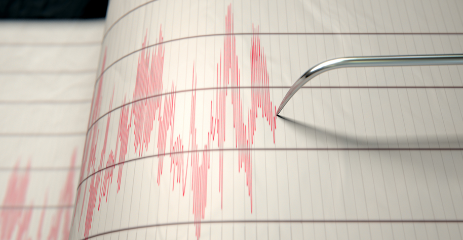
The Richter Magnitude scale was developed in 1935 by Charles F. Richter of the California Institute of Technology and was followed later by many additional magnitude scales. The Moment Magnitude scale is used to rate the magnitude (the amount of energy released) of an earthquake, and is preferred by scientists to determine earthquake magnitudes today. Magnitude is not determined by assessing the damage caused by an earthquake but by using the shaking recorded at the surface as measured by instruments known as seismographs.(6)
Magnitude is expressed on the Moment Magnitude scale in whole numbers and decimal fractions. A whole number increase in magnitude represents a tenfold increase in measured energy. Each whole number step in the magnitude scale corresponds to the release of about 31 times more energy than the amount associated with the preceding whole number value.
Another important scale used by earthquake scientists is the Modified Mercalli Intensity (MMI) scale. The MMI scale estimates the intensity of shaking in the region around the earthquake epicenter with a range of values that varies across the landscape corresponding to felt reports of shaking and damage.
An earthquake with a magnitude of 6.7 struck the southern California city of Northridge in 1994. The quake killed 57 people, injured more than 9,000, and displaced over 20,000. It caused an estimated $20 billion in property losses and infrastructure damages. It is considered the costliest earthquake in U.S. history.(7)
As a result, building codes changed and retrofitting was done at hospitals and on freeways and water pipes to mitigate (or reduce) the effect of the next earthquake.(8, 9) State and local responders are prepared for the next earthquake with emergency plans and early warning systems, like the MyShake App.
Thanks in advance for your questions and comments on this Public Health Matters post. Please note that the CDC does not give personal medical advice. If you are concerned you have a disease or condition, talk to your doctor.
Have a question for CDC? CDC-INFO (http://www.cdc.gov/cdc-info/index.html) offers live agents by phone and email to help you find the latest, reliable, and science-based health information on more than 750 health topics.
Last year’s Atlantic hurricane season was record-breaking. There were 30 named storms during the 2020 season. Thirteen of those became hurricanes (top winds of 74 mph or greater). Six of those reached Category 3 or higher.(1)
Hurricanes are categorized using the Saffir-Simpson Hurricane Wind Scale. Other scales are used by experts to explain and describe the intensity or severity of disasters like tornadoes and earthquakes. Below are descriptions of some of them.
The Saffir-Simpson Hurricane Wind Scale
The Saffir-Simpson Hurricane Wind Scale was created in 1971 by civil engineer Herbert Saffir and meteorologist Robert Simpson. Hurricanes are rated (or categorized) 1 to 5 based on their maximum sustained wind speed. The category relates wind speed to the kinds of property damage that are likely to occur from wind.(2)
All hurricanes produce life-threatening winds, but only storms rated Category 3 and higher are considered major hurricanes. Major hurricanes cause devastating to catastrophic wind damage.
Hurricanes of all categories can produce storm surge that requires people to evacuate and take other preventative measures.
The Saffir-Simpson scale only provides information about wind damage. It does not describe damage from other hazards, such as storm surge, inland flooding, or tornadoes spawned by the storm.
Along the coast, storm surge is often the greatest threat to life and property from a hurricane. At least 1,500 people died during Hurricane Katrina in 2005. Many of those deaths are attributed either directly or indirectly to storm surge.(3)
Evacuation orders are more likely to be based on storm surge or inland flooding than on the Saffir-Simpson category. It is critical for emergency officials and the public to stay informed of the forecast and to prepare regardless of whether they live near the coast or well inland.
Researcher Ted Fujita and Allen Pearson of the National Weather Service (NWS), introduced the original Fujita Scale for rating tornadoes in 1971.
Wind researchers and engineers provided substantial enhancements to the scale in the early 2000s, called the Enhanced Fujita (EF) Scale. NWS adopted the scale in 2007. Like the F-Scale, the EF Scale estimates a tornado’s intensity on a scale, from 0 to 5, based on surveyed damage.(4)
Photo credit: FEMA
NWS is the only federal agency with the authority to provide official ratings for tornadoes. Ratings are not based on actual measurements of wind speed; although, some researchers have equipment that can estimate speeds through radar velocity data. Ratings are estimates of wind speed based on assessed damage to structures and vegetation. The result is a range of likely
wind speeds.
The most recent EF5 tornado struck Moore, Okla., in May 2013.(5) It killed 24 people, injured many more, and caused billions of dollars in damage. After that tornado, the City of Moore passed building codes requiring new homes be built to withstand at least EF2 wind speeds.
The Richter Magnitude scale was developed in 1935 by Charles F. Richter of the California Institute of Technology and was followed later by many additional magnitude scales. The Moment Magnitude scale is used to rate the magnitude (the amount of energy released) of an earthquake, and is preferred by scientists to determine earthquake magnitudes today. Magnitude is not determined by assessing the damage caused by an earthquake but by using the shaking recorded at the surface as measured by instruments known as seismographs.(6)
Magnitude is expressed on the Moment Magnitude scale in whole numbers and decimal fractions. A whole number increase in magnitude represents a tenfold increase in measured energy. Each whole number step in the magnitude scale corresponds to the release of about 31 times more energy than the amount associated with the preceding whole number value.
Another important scale used by earthquake scientists is the Modified Mercalli Intensity (MMI) scale. The MMI scale estimates the intensity of shaking in the region around the earthquake epicenter with a range of values that varies across the landscape corresponding to felt reports of shaking and damage.
An earthquake with a magnitude of 6.7 struck the southern California city of Northridge in 1994. The quake killed 57 people, injured more than 9,000, and displaced over 20,000. It caused an estimated $20 billion in property losses and infrastructure damages. It is considered the costliest earthquake in U.S. history.(7)
As a result, building codes changed and retrofitting was done at hospitals and on freeways and water pipes to mitigate (or reduce) the effect of the next earthquake.(8, 9) State and local responders are prepared for the next earthquake with emergency plans and early warning systems, like the MyShake App.
Thanks in advance for your questions and comments on this Public Health Matters post. Please note that the CDC does not give personal medical advice. If you are concerned you have a disease or condition, talk to your doctor.
Have a question for CDC? CDC-INFO (http://www.cdc.gov/cdc-info/index.html) offers live agents by phone and email to help you find the latest, reliable, and science-based health information on more than 750 health topics.
Speaking of earthquakes, Will Chase looked back at a 2012 earthquake in Sumatra that triggered not only a bunch of small ones in the vicinity, but other large ones around the world:
In the ten days following the Sumatra mainshock, 44 earthquakes M5.5+ were recorded. The statistics were clear: this nine-fold increase was highly significant, and most researchers agreed the likely explanation was remote triggering by the M8.6 Sumatra earthquake. This massive triggering of large earthquakes was unprecedented, and many wondered if the strike-slip mechanism at such a large magnitude was a unique combination that led to this outsized response.
Living in California, I’ve experienced a handful of these, but it had been a while before feeling one a few weeks ago. I may or may not have immediately started looking at earthquake insurance.
On a cold January night in an icy church in Boston, I stood amongst more than a hundred Haitian community members feeling a strange proximity to the tragic earthquake that struck earlier that day in a hot distant island about which I knew little at the time. The 2010 earthquake in Haiti occurred when I was exploring the field of public health and working in the Commissioner’s Office at the Massachusetts Department of Public Health (MDPH).
New to public health at the time and with the events unfolding so rapidly, there were many aspects of the response that hold a lot more meaning to me now that I more regularly engage in emergency response work. From this experience I gained new perspectives and lessons on the impact of a local response to the international disaster. The impact of the Haiti earthquake on Boston’s Haitian community offered a unique view of how a state health department can respond to an international emergency to serve diaspora populations within its borders, the importance of mental health in emergency preparedness and response, and community resilience.
The Initial Role of the State
Reporters covering the international response to the 2010 Earthquake in Haiti.
It was unclear at first what role the state should have. Massachusetts has one of the largest Haitian diaspora populations in the US with about 150,000 Haitian Americans. It also has some of the nation’s top hospitals and international organizations, including Partners in Health, which was already an established medical entity in Haiti. Within 24 hours of the earthquake, key public officials in Boston began emergency coordination meetings discussing options for airlifting victims to Boston hospitals and for sending supplies and volunteer health workers to Haiti. Ultimately, MDPH took a coordination and communication role in the first 48 hours. The Health Department answered questions from the public and from potential donors and volunteers and coordinated responses with other federal agencies. But as more and more calls came in from Haitians living in Massachusetts, it quickly became clear that this was an international emergency impacting the local population. It was not the conventional type of emergency for which states typically plan and are funded.
The Commissioner of Public Health for the Commonwealth of Massachusetts, and my boss at the time, John Auerbach, summed up the experience saying, “We needed to be responsive to the behavioral health and other immediate needs that were associated with an event outside of our state and outside of the nation. We hadn’t anticipated that a global event could require this type of internal state-specific emergency response. But that was the case.”
Creating Communication Networks
Call center volunteer.
Haitian Americans desperately tried to locate friends and family members in Haiti and, in some cases, get them medical care. Working with CDC and HHS’ Office of the Assistant Secretary for Preparedness and Response (ASPR), MDPH reallocated emergency funds to address the needs for this unique situation, where the event occurred in another country but assistance was needed at home. A complex data system was established that allowed individuals to enter the name of a missing person in an attempt to match records on the ground and locate the missing. A hotline of volunteers speaking Creole, French, and English provided mental health counseling and answered questions about the situation in Haiti. Haitian community-based organizations received mini-grants to provide onsite support to grieving community members, hold support groups, and build community resiliency. The state collaborated with Haitian-American groups to give daily briefings in Creole to keep the community informed.
Medical Care and Relocations
Another aspect of the response was to coordinate reunification, transport and housing for long-term medical care for Haitian American victims of the earthquake. Additionally, an influx of Haitian children orphaned by the earthquake were adopted by relatives in Massachusetts. MDPH worked with federal authorities to approve cases for transport and worked with schools and communities to maintain vaccination records and address mental health and cultural needs in the classroom.
Lasting Impressions
This was my first experience as a professional working on an emergency response, and it inspired my career path and my approach to cultural competence and working with vulnerable populations in a crisis. The earthquake highlighted how mental and behavioral health needs to be included in emergency planning–trying to address these needs in the midst of a crisis is challenging and potentially harmful. It also demonstrated the importance of adaptability when responding to an emergency. There was not a set plan for a local response to an international emergency, but a response was needed in this case. In addition, all aspects of the response needed to match Haitian culture, heritage, and language.
I think Mr. Auerbach said it best in his reflection of MDPH’s response to the Haiti Earthquake, “We prepare for all-hazards but need to be flexible and aware that work plans can completely change. The response is more important than the plan.”